How To Find Your Property On FEMA’s Flood Insurance Rate Maps

What are FEMA flood maps?
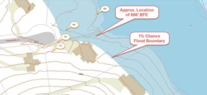
FEMA’s Flood Insurance Rate Maps (FIRMs) or just Flood Maps are provided after a flood risk assessment has been completed or updated for a community.  This study is known as a Flood Insurance Study.  The FIRM gives you the Base Flood Elevations (BFEs) and insurance risk zones in addition to floodplain boundaries.  The FIRM may also show a delineation of the regulatory floodway.

Once the “insurance risk zone”  (commonly referred to as the flood zone) is determined, actuarial rates, based on these risk zones, are then applied for newly constructed, substantially approved, and substantially damaged buildings.  FEMA uses these rates to determine the insurance rate you will pay for flood insurance

FEMA’s Digital Flood Maps

FEMA discontinued the production and distribution of paper flood maps in 2009 as part of its Digital Vision Initiative. This affected all the Flood Maps, boundary information, and study reports. However, clients can still view the products for free through their website or buy them in digital format.

To view these flood maps online, go to FEMA’s Map Service Center and key in your address (hi-lited area shown here) search for your home.  This will prompt you to then select the map that covers your area.  The Flood Maps are somewhat cumbersome to use online. It is best to go through the tutorial on the bottom right of the address search page for an easier and more effective use of the GIS map.

author avatar
Surveyor

More Posts

A construction survey technician using ground penetrating radar to map underground utility lines before excavation
land surveying
Surveyor

Why a Construction Survey Matters in the Lead Pipe Crisis

Chicago’s lead pipe crisis keeps making headlines, but most people still miss the real problem hiding under the streets. Everyone talks about the aging water lines and the huge cost of replacing them. However, the part that slows everything down isn’t plumbing. It’s the lack of accurate underground maps. That’s

Read More »
Home inspector reviewing a loan closing survey in front of a house
alta survey
Surveyor

Why a Loan Closing Survey Can Protect Your Closing

If you plan to sell or refinance your home, now is the right time to get a loan closing survey. Cook County will send out its second property tax bills for 2024 on November 14, and payments are due by December 15. With the bills coming late and deadlines getting

Read More »
A land surveyor in safety gear using a laptop to record boundary survey data along a shoreline during an environmental cleanup
boundary surveying
Surveyor

How a Boundary Survey Guided a Major Spill Cleanup

When a half-million gallons of liquid asphalt spilled into the Chicago Sanitary and Ship Canal near Forest View, the city faced more than just a cleanup. Crews needed to know exactly where the spill spread, who owned the affected land, and which agencies were responsible for fixing it. That’s where

Read More »
Drone surveyor capturing aerial data over a river valley to monitor shoreline elevation changes after a seiche
land surveyor
Surveyor

How a Drone Surveyor Restores Accuracy After a Seiche

When Lake Michigan suddenly dropped last week, it surprised many Chicago residents and contractors. The National Weather Service said it was a seiche — a quick rise and fall in water levels caused by strong winds and air pressure shifts. The main reports came from Lake Erie, but the same

Read More »
Surveyor on site using total station equipment during a funding freeze affecting alta title survey projects
alta survey
Surveyor

How a Funding Freeze Delays ALTA Title Survey

Chicago’s Red Line Extension made headlines earlier this month—and not for the right reasons. Around $2 billion in federal transit funding remains on hold after a White House spending freeze, creating uncertainty for contractors, developers, and surveyors across the city. At first glance, this sounds like a transportation issue. But

Read More »
Aerial view of residential homes near a river showing different elevations and potential flood risk areas relevant to FEMA elevation certificate.
flood damage
Surveyor

FEMA Elevation Certificate: Keep Closings Moving

Buying a home is stressful enough. Add a flood insurance freeze into the mix, and you’ve got chaos. In the last few days, the federal government’s shutdown caused the National Flood Insurance Program (NFIP) to pause new and renewed policies nationwide. That’s bad news for anyone trying to close on

Read More »