Chicago’s downtown blocks don’t leave much room to breathe. Buildings sit shoulder to shoulder. Sidewalks squeeze between loading docks, utility vaults, and alleys barely wide enough for a truck. When a redevelopment project lands on one of these parcels, reviewing the site the old way gets slow. Walls block sightlines. Traffic blocks access. Every angle seems to hide something.
LiDAR mapping gives project teams a way to see what’s actually on a site before anyone touches it.
Seeing the Site Beyond Its Open Footprint
A tight redevelopment parcel rarely stands alone. It’s boxed in by neighbors on every side, and those neighbors matter to the project.
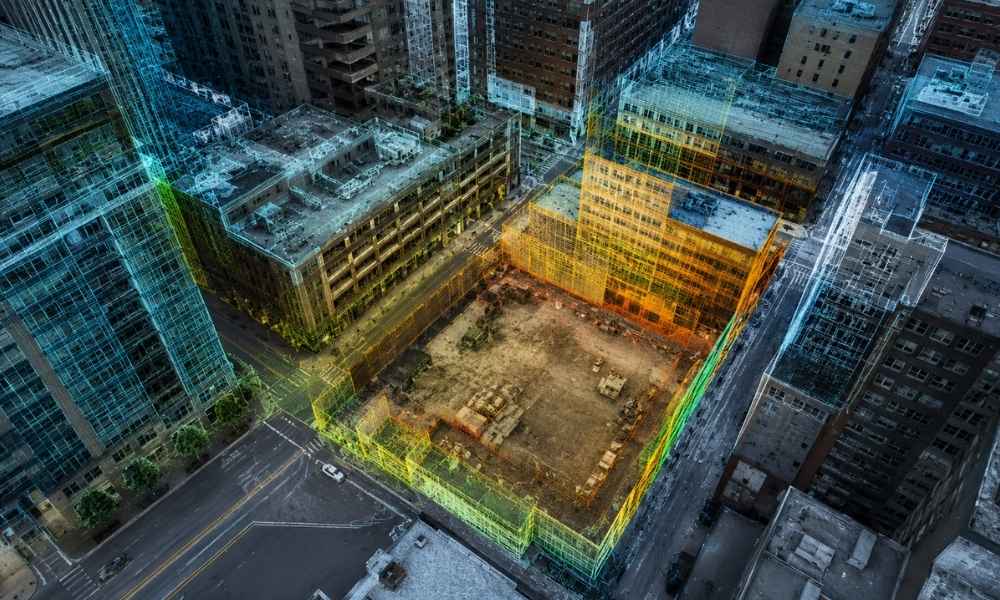
LiDAR mapping builds a dense set of spatial measurements across the whole area, not just the empty lot itself. That gives a reviewer a way to study:
- Buildings that sit close to the property line
- The faces and outer walls of nearby structures
- Pavement, curbs, and other hard surfaces
- Narrow gaps between buildings or along alleys
- Small changes in ground shape that are easy to miss on foot
- Anything sitting just outside the redevelopment footprint that could affect the design
None of this replaces walking the site. But it gives a reviewer a clear picture of the space around a project before they set foot on it, which cuts down on guesswork once design work starts.
Comparing Existing Conditions With the Redevelopment Concept
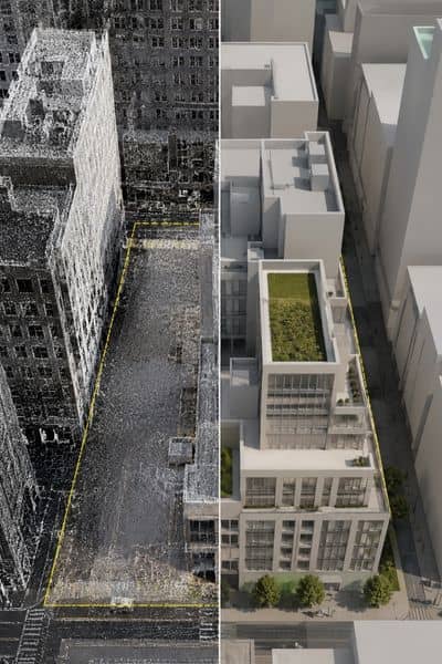
Once a design team has a concept sketch, the real question is whether it actually fits the site. This is where LiDAR-derived data earns its keep.
Architects, engineers, and developers can lay the proposed design over the mapped existing conditions and check things like:
- Does the proposed building massing fit inside the available space?
- Are existing structures actually where the site plan says they are?
- Are there walls, footings, or other physical items in the way of the planned work area?
- Which parts of the site still need someone to go out and check by hand?
This step is different from a topographic survey. A topo survey maps contours, spot elevations, utilities, and buildings on their own. This step takes that mapped information and puts it next to the design, so the team can catch conflicts early instead of finding them mid-construction.
Working Around Chicago’s Limited Site Access
This is where a lot of downtown redevelopment projects run into trouble.
A site in the Loop, River North, or along the river might be boxed in by active buildings on three sides, a busy street on the fourth, and no real place to stage equipment. Sending a crew in to measure every corner by hand can mean shutting down a sidewalk, coordinating with a neighboring property owner, or working around business hours. Sometimes there’s barely enough room to set up a single instrument.
LiDAR mapping can pull spatial data from areas that are hard to reach on foot, whether that’s a narrow side yard, a rooftop setback, or a gap between two buildings that’s too tight to walk through safely. That doesn’t mean field surveying goes away. It means the field crew can go in later with a shorter, more focused list of what still needs to be measured by hand, instead of trying to capture the entire site blind.
For a project team planning site access in a dense part of the city, that shorter list matters. It can mean fewer permits for lane closures, less time coordinating with neighbors, and a field visit that’s over faster because the crew already knows what they’re looking for.
Finding the Places That Need a Closer Field Check
LiDAR mapping is a screening tool. It’s not a stand-in for a licensed surveyor’s judgment, and it shouldn’t be treated as the final word on every part of a site.
What it’s good at is flagging where a closer look is worth the time. A redevelopment team can use the mapped data to spot:
- Areas where the shape or edge of a structure isn’t clear
- Spots where the mapped data doesn’t match old site plans or drawings
- Tight transitions where one building meets another
- Features that matter to the new design, like a shared wall or a setback line
- Any area where the data just needs a second set of eyes to confirm it
This matters for another reason too. Remote sensing and laser-scanning methods, including LiDAR, come with limits on precision and completeness. Depending on how the data will be used, especially for certain survey purposes like an ALTA/NSPS Land Title Survey, those limits need to be disclosed and accounted for. A good LiDAR dataset tells a project team where to look closer. It doesn’t replace the surveyor who confirms what’s actually there.
Building a More Useful Existing-Conditions Picture
LiDAR mapping doesn’t replace an ALTA survey, a boundary survey, a topographic survey, or a surveyor standing on site with a level and a rod. That’s not the point.
The point is that a dense, accurate picture of what already exists on a tight urban site gives a project team something to work from before the design gets locked in. On a redevelopment site, where every foot of space counts and access is often limited, that early picture can mean fewer surprises once permits are filed and crews show up to start work.
For property owners, developers, and design teams working on a constrained downtown parcel, that’s the real payoff: knowing what’s actually there before the decisions that are hard to undo get made.